The Sahara (13 page)
Authors: Eamonn Gearon
Tags: #Travel, #Sahara, #Desert, #North Africa, #Colonialism, #Art, #Culture, #Literature, #History, #Tunisia, #Berber, #Tuareg

As for al-Idrisi, it genuinely is hard to overstate his importance in the world of medieval cartography. Working as the permanent secretary of an academy of scholars, al-Idrisi had the task of producing the finest, most extensive work of geography in history. Using existing Muslim and non-Muslim sources and information gleaned from contemporary travellers, the academy took fifteen years to produce
The Delight of One Who Wishes to Traverse the Regions of the World
, more banally referred to as
The Book of Roger.
Consisting of seventy double-spread page maps, aligned “upside down”, that is with south at the top of the page as opposed to the modern north-south orientation, each map came with latitudes marked and distance between towns, as well as a descriptions of these. The book was the marvel of its day and although it has been criticized for not drawing more widely on existing geographers-especially as al-Idrisi claims it was “an exhaustive and detailed investigation”-the work remains peerless. Among the Saharan locations that al-Idrisi mentions is the old capital of the Ghana Empire, near Timbuktu, which he describes as being “the most considerable, the most densely peopled, and the largest trading centre of the Negro countries.” One of the most notable geographical features that al-Idrisi successfully plots is the course of the Nile and its source in the African lakes, which Burton and Speke would only “discover” seven centuries later. He was not always so accurate, however. Writing about the River Niger, which he calls, “the Nile of the Negroes”, al-Idrisi imagines that it traverses the Sahara from west to east before connecting with the River Nile at some unknown point.
As well as the book, al-Idrisi created a version of his atlas for Roger inscribed on a solid silver disc that measured six feet in diameter, weighed 450 lb. and was the first known attempt to produce a true globe. After Roger’s death in 1154, his son William the Bad commissioned al-Idrisi to write another book. The resultant work was accorded the gloriously descriptive tide
Gardens of Pleasure and Recreation of the Souls,
and although it was said to include more information on various Saharan locations, no trace of the work remains.
Among the otherwise sparse textual records about the Sahara of the twelfth century, we are fortunate that the work of the Jewish traveller Rabbi Benjamin of Tudela, in the Kingdom of Navarre, has survived. Although only a small part of his account, The
Book of Travels
or
Book of Benjamin
, deals with the Sahara, it highlights the difficulties inherent in Saharan travel and the potential trading rewards found at the end of the journey:
[From Helwan, Egypt) people travel in caravans a journey of 50 days through the great desert called Sahara, to the land of Zawilah [Libya], which is Havilah in the land of Gana [near Sabha, Libya). In this desert there are mountains of sand, and when the wind rises, it covers the caravans with the sand, and many die from suffocation. Those that escape all manner of lentils, and bring back with them copper, wheat, fruit, salt. And from thence they bring gold, and all kinds of jewels.
Like other writers whom we rely on for our knowledge of the Sahara at this time, Benjamin did not travel extensively in the desert but he obviously spent time talking to those who did, recording their impressions and noting comments from other travel literature extant in his day. By the late Middle Ages, translations of Benjamin’s account, originally written in Hebrew, had appeared in numerous languages and were widely consulted across Europe.
Yaq ut al-Hamawi, born in 1179, was sold into slavery early in his life. Fortunately, his master recognized his intelligence and educated al-Hamawi before eventually freeing him. Posterity, too, has been rewarded by the actions of al-Harnawi’s master; the sometime slave put his education to use in producing the first proper encyclopaedia of the Muslim world. Not only was this a novel way to arrange his material, but al-Hamawi’s work,
The Book of Countries
, is just as important for the large number of sources it uses, combining as it does Greek and Arabic scholars on science and cosmology. The book is also full of knowledgeable and descriptive geographies and, like Herodotus, many diversions including the histories and mythologies of the places he visited and ethnographic observations of their peoples. Obviously enamoured with the encyclopaedic form, Yaq ut also wrote a
Dictionary of Learned Men
. He died in 1229.
Of all the travellers and scholars from these centuries of - Andalusia aside - European ignorance, the most noted is Ibn Battuta, the greatest traveller of his or any time. Ibn Juzayy, who transcribed and edited Battuta’s work, observed that, “this sheikh is the traveller of his age”. In the twentieth century the historian George Kimble wrote: “The Arabs had reserved their best wine until last. After Battuta they can boast few... travellers or writers of repute.” Born in Tangier in 1304, by the time of his death in 1368 or 1369 Ibn Battuta had travelled an estimated 75,000 miles in three decades, more than his near contemporary Marco Polo; and unlike Polo, Battuta’s accounts of the places he saw are not riddled with falsehood and fantasy. After 24 years away from home, he only stayed for a month before crossing the Sahara to Timbuktu.
His Saharan journeys alone lasted nearly three years. En route to Timbuktu he visited the once famous but latterly abandoned salt-mining oasis of Taghaza in modern day northern Mali. Echoing the thoughts of many travellers in the Sahara before and since, Battuta wrote of this remote spot: “We passed 10 days of discomfort there, because the water is brackish and the place is plagued with flies.” He added that it is “haunted by demons... There is no visible road, nothing but sand blown hither and thither by the wind” - which considering how challenging his wanderings had been goes some way to illustrate the region’s desolation.
One thing which particularly interested Battuta while he travelled in the Sahara - what he called “a strange thing” - was a blind guide: “Our guide was blind in one eye and diseased in the other, but he knew the route better than anybody else.” Battuta would not be the last to make this observation. Blind or virtually sightless guides have been encountered in every part of the Sahara. Even up to the present day travellers have recorded the presence of such individuals, some of whom will sniff the sand before announcing in which direction a party ought to travel or how far they might be from their destination.
Recalling the oasis of “Iwalatan”, also spelt Walata, Wualata or Oualata, in south-east Mauritania, Battuta refers to it as “the northernmost province of the negroes”. Since the thirteenth century this oasis had grown in importance as the terminus for one of the busiest trans-Saharan routes. Just how extensive trans-Saharan trade was is clear from Battuta’s observation that “The garments of its inhabitants... are of fine Egyptian fabrics.” Regardless, he was not impressed by the location; even worse, he was deeply offended by the behaviour of the local ruler. In what was clearly a case of cultural misunderstanding, Battuta was annoyed that the sultan’s representative would only speak to him via an interpreter, even though they could both speak Arabic. Battuta calls this deliberate rudeness, ignoring the possibility that it might just be the local custom when communicating with the ruler’s envoy: “The merchants remained standing in front of [Hussein] while he spoke to them through an interpreter, although they were close to him, to show his contempt for them. It was then that I repented of having come to their country, because of their lack of manners and their contempt for the whites.” (Battuta clearly thinks of himself as being among the “whites”, distinct from the black locals.)
Battuta’s account of Timbuktu disappoints many readers, but at the time of his visit the city was just emerging as an important centre of trade and scholarship. His description of the oasis is most pedestrian, but properly reflects the state of the town at that time: “Thence we went on to Timbuktu, which stands four miles from the river [Niger].” After recording the name of the local ruler and some details of limited interest, Battuta concludes his report by saying: “In this town is the grave of the meritorious poet Abu Ishaq as-Sahili, of Gharnata [Granada], who is known in his own land as at-Tuwayjin [Little Saucepan].” Battuta found Timbuktu to be the unimportant backwater it was then, with little to excite even the greatest traveller and one of the most enquiring minds, of his time. His description is obviously not the stuff that would later drive countless European adventurers and explorers to their death. However, had he returned two hundred years later, Battuta would have found it utterly changed , grown wealthy and filled with the bustle of trade and learning. Within two centuries a dusty oasis near a river had been transformed into the pearl of Saharan destinations. Yet it should be remembered that Timbuktu , whatever place it enjoyed in the European imagination, was only one city among a number of important medieval Saharan empires.
Gilded Empires
“Then I rais’d
My voice and cried, ‘Wide Afric, doth thy Sun
Lighten, thy hills enfold a City as fair
As those which starr’d the night o’ the elder World?
Or is the rumour of thy Timbuctoo
A dream as frail as those of ancient Time?’”
From Alfred Tennyson, “Timbuktoo” (1829)
If you feel that, until now, the Sahara’s north has received an unfair amount of attention over the south you would be right. And the reason is that the Egyptian, Greek and Roman civilizations left behind a far greater body of textual and other material records than their southern Saharan contemporaries. Inevitably, therefore, the northern powers had a greater cultural impact.
The three above-named northern empires also had greater influence in terms of range and duration than any of their counterparts in the south. For one thing, trade along the coastal regions, whether by land or sea, was easier than through the desert. While at no point in the history of the Sahara was the desert a solid barrier between north and south, as the region became increasingly arid the difficulties associated with travel inevitably increased. After the camel was introduced and became firmly established in the region, this situation changed. If knowledge that the arrival of the camel in the Sahara would effect change was not surprising, the speed with which it did so was perhaps more unexpected. The conditions surrounding the increasingly unfavourable climate and progressively complicated cross-desert communications that resulted had long meant that there existed an imbalance in power across the Sahara, which was broadly to the detriment of the south and of benefit to the north.
With camels, men were regularly making their way back and forth across the Sahara, with increasing confidence if not ease, for the journey remained (indeed remains) a demanding one. As they transported ideas and knowledge just as often and as easily as trade goods, large swathes of the desert underwent an economic and intellectual revolution. It is no exaggeration to say that the radical changes that took place across the Sahara from the tenth century did so on the back of camels. The significant economic shifts that resulted from trans-Saharan paths becoming to some extent easier to traverse had political fallouts as well as economic. As goods readily accessible in the south were traded in greater quantities, burgeoning empires there, across the continent’s so-called Sudanic belt, soon found themselves exerting greater influence over their northern neighbours.
One of the earliest of these southern Saharan states, whose sway extended beyond its borders, was the Ghana Empire, which initially flourished from roughly 790 until the second half of the eleventh century. Then the empire rose again under the Sosso people, once a part of the collapsed Ghana Empire, before finally ceasing to exist as an independent power when it was subsumed into the Mali Empire in 1240. Not to be confused with the modern nation of the same name, at its greatest extent the Ghana Empire covered large areas of contemporary south-eastern Mauritania and western Mali, and it grew strong because of its location and the important commodities that lay within its borders.
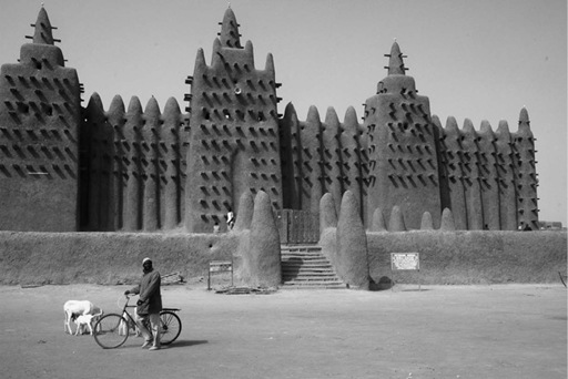
The Great Mosque, Djenné
The Kingdom of Ghana contained numerous mines with an abundance of gold and salt and several important oasis towns, southern termini of the busiest trans-Saharan trade routes. Then as now, these were two of the most precious commodities under the face of the earth. Once the knowledge of how to mine them was married to control of the export routes across the desert, the kingdom’s resultant power was irresistible for nearly three hundred years.