The Rocks Don't Lie: A Geologist Investigates Noah's Flood (34 page)
Read The Rocks Don't Lie: A Geologist Investigates Noah's Flood Online
Authors: David R. Montgomery
Tags: #Non-Fiction, #Religious Studies, #Geology, #Science, #21st Century, #Religion, #v.5, #Amazon.com, #Retail

It took several more decades to develop a valid explanation of just how mountains arose. The answer was plate tectonics. In fact, the theory of plate tectonics came together to explain three independent mysteries that only made sense when considered together—high heat flow over submarine mountain ranges out in the middle of the oceans, a bar-code-like pattern of magnetic stripes on the seafloor, and the global distribution of earthquakes. Different groups of scientists working in different places, on different problems, with new technologies independently discovered the pieces needed to solve the grand puzzle of what caused continents to move across Earth’s surface.
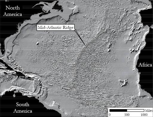
Before sonar, seafloor topography was veiled beneath the waves, essentially unknown in deep water away from reefs and oceanic islands. The development of sonar opened an entirely new view of the seafloor. Widely used during the Second World War as a form of underwater radar to hunt enemy submarines and help better target surface ships, sonar also could be used to map the depth of the seafloor. The idea behind sonar is simple: bounce a pulse of sound off something and measure how long it takes for the echo to come back. Knowing the speed of sound you can then determine the distance to the reflector. The process is similar to the navigation method used by bats. When oceanographers began systematically mapping the seafloor, they discovered something they could not explain. Hidden from view, under miles of water in the depths of the world’s oceans, linear chains of mountains circled the world like the stitching on a baseball. If this wasn’t odd enough, the spines of these ranges were always a long valley with extremely high heat flow and active rift volcanism. The ocean floor was spreading apart, generating new oceanic crust along mid-ocean ridges.

Map of the Mid-Atlantic Ridge in the North Atlantic Ocean.
The second piece of the puzzle followed the development of magnetometers that could detect subtle differences in the strength and the sign (positive or negative) of magnetic fields. Detecting the magnetic signatures of submarines proved to be an excellent way to track and sink them—if one could discern their signal from the background magnetic signature of the seafloor. For that it was useful to have a map of oceanic magnetism. The navy’s program to map the magnetic signature of the seafloor produced another surprise. As researchers surveyed away from mid-ocean ridges, they found alternating bands of different magnetic polarization—stripes with normal magnetic polarity alternating with stripes of negative polarity. The scientists who first reported the odd zebra-hide pattern of magnetically striped seabed sections noted that they had no idea how to explain it. A decade later, the stripes were understood to be like a strip-chart recording of global reversals in Earth’s magnetic field. Imprinted with the planet’s magnetic field—positive or negative—when they first cooled, the newly formed rocks at the mid-ocean ridges slowly moved away from the ridge as new crust squeezed up at the ridge and pushed older crust out of the way.
The discovery of how and where earthquakes are produced provided the final critical piece of the tectonic puzzle through efforts to verify nuclear test ban treaties. The discovery that underground nuclear tests produced seismic waves that could be distinguished from the seismic waves produced by earthquakes fueled substantial government investment in seismology in the 1950s and 1960s. Ratification of the Limited Test Ban Treaty in 1963 made continuous seismic monitoring and locating of earthquakes critical to verifying treaty compliance. Establishment of a global seismograph network led to a rapid increase in the global catalog of earthquake locations, revealing a striking pattern. Most earthquakes occurred in the uppermost several hundred miles of Earth’s crust. But there was no good explanation for mysterious deep earthquakes triggered more than four hundred miles below ground. The rocks that far down should be too hot and mushy to sustain the rigid deformation needed to produce earthquakes. As seismologists refined their methods, they found that these unusually deep earthquakes outlined slabs of crust sinking down into the planet’s interior.
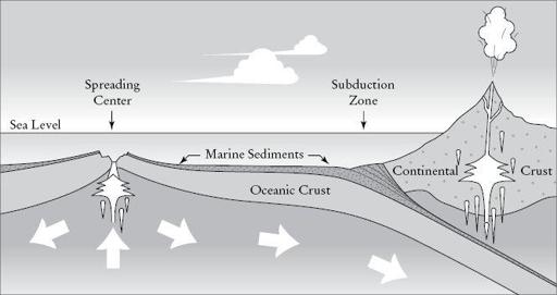
These three seemingly unrelated observations—the birth of new oceanic crust at spreading centers in the middle of the oceans, the slow movement of new crust away from the spreading centers, and the sinking of crust beneath continents in subduction zones along the ocean margins—defined a full cycle. New crust was rising up in the middle of the ocean and sinking back down to be recycled in the deep trenches at the edge of ocean basins. Crust produced at mid-ocean ridges was being pushed aside until it ran into a lighter continent and got shoved back down into the mantle. Continents rafted along on mobile plates of crust spread apart and collided with each other, pushing up mountains and continually resurfacing the planet over geologic time. Here was a single, grand mechanism to explain not only how continents moved around but how mountains formed, where different rock types occurred, and why earthquakes, volcanoes, and mountains all line up where plates split apart, collide, or slide past one another.
In contrast to the long list of fundamentally irreconcilable problems with the concept of a global flood—such as where the water came from and where it went after the flood, the order of the fossil record, the predominance of extinct species in the fossil record, and the presence of soils and burrows developed on sedimentary rocks—plate tectonics provides remarkably consistent explanations for a wide range of phenomena. It explains why Africa and South America look like they fit together like the pieces of a jigsaw puzzle, only separated by the Atlantic Ocean. It explains the sequences, ages, and assemblages of rocks one finds throughout the world, as well as the global distribution of topography. Plate tectonics revolutionized geology, elegantly explaining within a single framework many of the physical world’s outstanding mysteries.

Illustration of how mid-ocean spreading centers connect to subduction zones to define the upper half of deep Earth circulation that drives plate tectonics and rafts continents along as oceanic crust moves laterally
(
based on a sketch by Véronique Robigou
).
In the early 1970s, as plate tectonics was revolutionizing the earth sciences, James Moore, a lecturer in history of science and technology at England’s Open University, emphasized the ongoing threat dogmatic theology posed to evangelical thought in the
Evangelical Quarterly
.
Scientists and theologians who are Christians too often neglect history to their own intellectual condemnation. What appear to them to be major modern issues on which turns the perspicuous truth of biblical revelation are often problems which were long ago laid to rest. They realize too late that their labored polemics and hastily written tracts are little more than exuberant rehashes of what was once conclusively argued or contravened. This is unforgivable. They should have known that, without historical sense, it is not only possible but inevitable that men repeat the very errors which once discredited their forbearers.
9
Like their seventeenth-century predecessors, the imagination of modern creationists knows no bounds. The impressive variety of explanations they invoke for substantiating literal interpretations of Noah’s Flood as a global catastrophe include collapse of a globe-shrouding vapor canopy, eruption of supergeysers from the earth’s core, and bombardment by asteroids striking the world’s oceans. Apparently, a literal reading of the Bible still leaves a lot of room for creative interpretation.
Rocks, on the other hand, do not. When a colleague and I were leaving the Creation Museum, he pointed out the 440-million-year-old, trilobite-bearing limestone exposed in a road cut. This ancient seabed from the proto-Atlantic Ocean is exposed for hundreds of miles across Ohio, Kentucky, and Indiana. These rocks are clearly not a chaotic, mixed-up product of an earth-shattering flood. They formed when an ancient sea gradually accumulated, layer by layer, to form a thick pile of sediment stretching from Newfoundland to Alabama. What better testimony could be offered to the irreconcilable differences between geology and creationism than the fact that the Creation Museum itself is built upon rocks that dispute the version of earth history displayed within its walls?
But without a theoretical framework for interpreting their observations, geologists can misread the stories inscribed in the rock record. Only when the idea of plate tectonics came to light was there a clear driving mechanism to explain the global distribution of topography and rock types. The difference between scientists and creationists, however, is that scientists assess their theories based on how well they fit the evidence, whereas creationists interpret observations by determining how well the facts fit in with their beliefs. Not surprisingly, these different varieties of faith yield radically different views of nature.
13

The Nature of Faith
T
HE PUSH-AND-PULL
, the back-and-forth through history between science and religion is more of a dance than a war. I now think of it as an awkward egalitarian waltz, with the partners trading off the lead, sometimes moving one step ahead, other times following behind, and occasionally stomping on each other’s toes. Science and religion share humanity’s strong desire to understand our world, and as is the case with Noah’s Flood, much of the conflict we perceive between them occurs over how to interpret ancient stories in light of modern knowledge.
What more can we learn from the story of Noah’s Flood? Even though we can no longer read the story literally, we can still learn from it—all of us. The story of the biblical flood story shows how it is as important for scientists to maintain flexibility of interpretation when facing new data as it is for theologians who don’t want to be backed into making implausible arguments, like having to claim that rocks lie.
In our journey through the history of flood stories, we have seen two different ways of viewing faith—faith in a method or process (like science) and faith in a particular idea, view, or conclusion (like scientific theories or religious beliefs). Based on the idea that open inquiry promotes learning, scientists put evidence first to formulate and build upon theories. Evidence that does not fit a theory is scientific gold—it leads to new discovery and knowledge. In contrast, elevating preconceived ideas and beliefs above evidence shuts off learning and stifles curiosity about the world. Here lies the question at the border between science and religion. Is seeing believing, or is believing seeing?
Perhaps the conventional view of the centuries-long conflict between geology and Christianity should be viewed as more of a coevolutionary process. As geological interpretations of earth history evolved away from and evidence mounted against a single, worldwide deluge, Christians responded in three ways: some abandoned the Bible as an authoritative text; some tried to reconcile biblical and scientific views; and others simply rejected evidence they perceived to threaten biblical authority. These approaches correspond, respectively, to secular modernism, mainstream Christianity, and reactionary fundamentalism.