Read Supercontinent: Ten Billion Years in the Life of Our Planet Online
Authors: Ted Nield
Supercontinent: Ten Billion Years in the Life of Our Planet (9 page)

So geologists are still struggling with two types of change: gradual, repetitive Lyellian ones that go in cycles, and secular – one might even say ‘Suessian’ – changes: progressive, revolutionary once-and-for-all changes after which there is no going back. The history of the Earth is made of both.
In nature, cyclicity is going around all the time. Our Earth goes around the Sun and we have cycles called seasons. The Moon goes round the Earth and we have cycles called tides. Our planet rotates and we get cycles of day and night. This book is about the greatest cycle of nature: from one supercontinent, through phases of
breakup
, to the reassembly of a new supercontinent over a period of between 500 and 750 million years.
But there are plenty of examples of Suessian change too. Owing to the friction caused by the tides of the global ocean, the Earth is
rotating
more slowly today than it did yesterday. The moon’s orbit takes it a little further away from us each day. Days are longer now than they were 500 million years ago, which also means there were more days in the year back then. The Sun is gradually becoming hotter as it uses up its hydrogen fuel. And despite the delaying tactics of radioactivity, the Earth is indeed very gradually cooling down. Changes like this are one-way-only.
Cycles, however, were the essence of uniformitarianism as
presented
by Lyell. They allowed nature to repeat herself endlessly to the last syllable of time. What attracted Lyell to cases like the Graham Bank volcano and the ups and downs of the Bay of Naples was that they allowed him to make a subtly different point, namely that even if the rocks do speak of catastrophe, gradualism still
dominates
time.
The Vesuvius eruption of
AD
79 left a lot of geological evidence behind. Catastrophes often give rise to more evidence than the uneventful ages that pass between them. But this does not mean that the past was more violent than today; it just means that the rocks are unrepresentative. Like a scandal sheet called the
Geological Record,
rocks scurrilously report everything lurid and gruesome but leave out the everyday stuff. Lyell’s Earth was cyclic, placid even, and there was no progression, wave following on wave.
Suess wasn’t having this. His was a uniformitarianism for
revolutionaries
. For Suess there was more to existence than endless repetition. Not everything that goes around comes around. What happens today
can
make a difference, for ever. Suess rejected the idea that processes going on around us now are the
only
yardstick against which to measure the Earth’s massive history.
In reconstructing supercontinents even older than
Gondwanaland
, lands that existed when the Earth was very different, Earth scientists today are able to envision much stranger things than Lyell’s philosophy would ever allow them to dream of, and yet still keep their scientific heads. Suess, who also peered deeply into time, lacked the true Englishman’s fondness for the
status quo.
This man, who had stood on mountains and barricades, built aqueducts, tamed rivers and discovered a supercontinent, understood something Lyell did not: things need not always have been the way they are.
In mid-1960, engineers were carving out the Mont Blanc tunnel, which connects France and Italy, through the roots of the tallest Alpine massif. But on 14 July a small band gathered nearby to witness the End of the World, which was supposed to take place at 1.45pm. As the moment approached, women began wailing. A bugler in
lederhosen
stood up and delivered an impression of the final trump.
Then, unexpectedly, 2.46 arrived.
The cult leader, Elio Bianca, who before becoming a prophet had worked as a paediatrician with the Milan Electric Company, said afterwards: ‘We made a mistake.’ The next day the
New York Times
ran a story under the headline ‘
WORLD FAILS TO END
’. You could hardly ask for a more succinct statement of strict Lyellian uniformitarianism.
By contrast, the first people to climb Mont Blanc did so at the behest of a geologist, who was more anxious to know about how the Earth began. Horace Bénédict de Saussure (1740–99) put up two guineas for the first person to find a route to the top of ‘
la montagne maudite
’ (‘the accursed mountain’) after visiting Chamonix for the first time in 1760. It was twenty-five years before anyone made a claim, but in the end it was chamois hunter and crystal gatherer Jacques Balmat, together with a local physician, Michel-Gabriel Paccard, who became the first humans to stand at the summit, on 8 August 1786.
De Saussure himself gained the summit himself a year later and verified its height as 4785 metres (twenty-five metres short, but enough to put it in the record books). And although he later gave up trying to disentangle the fearsome structural complexity of the Alps, de Saussure summed up a whole tradition of European geology when he wrote: ‘It is the study of mountains which above all else can quicken the progress of the theory of the Earth.’ Understanding
mountains and the processes that build them was to unlock the tectonic enigma of how supercontinents form and break up. Crucially, mountains were soon to demonstrate the impossibility of up-
and-down
tectonics and foundered continents.
In almost his first geological assignment, Suess had discovered
evidence
of large
lateral
displacements in the Alps, which seemed to show that massive terrains had been moved sideways for large distances. In doing so he unwittingly planted the seeds of an idea that would unravel not only the structure of mountains but help lead
eventually
to the idea that continents themselves can move laterally. In later work and his
magnum opus
Suess did not ignore lateral
displacement
; instead he said it was a side effect of ups and downs. For him the basic force governing all tectonics was shrinkage, which caused large sections of the planet’s contracting crust to founder. As he put it, ‘The collapse of the Earth is what we are witnessing.’
As the Earth’s innards shrank, Suess believed, the crust was put under strain. From time to time parts of it would be forced to subside as the rocky outer shell accommodated to the collapsing planet within. The fragmentation of Gondwanaland, he reasoned, was caused by great subsidences, which left parts of the crust standing high as table-lands (Africa, India and South America) and parts deep below the sea. So the formerly connecting stretches of land in between, for example, Africa and South America, or India and Madagascar, had simply dropped and been lost beneath the waves. Gondwanaland had left fragments behind, but it had not
fragmented
. The lost parts of it were still there, sunk beneath the Indian and Atlantic oceans like the lost continents of myth. Because these foundered areas of new ocean were broadly elliptical, Suess said, they tended to leave behind landmasses with pointed ends: for the same reason that a round pastry cutter leaves you with triangular offcuts on the rolling board.
The idea of a shrinking Earth was a powerful one, because it seemed to flow, with all the inevitability of physical law, from the simple observation that it is hot in mines. The further down in the crust you go, the warmer it gets. Heat is escaping from the Earth’s interior. And to nineteenth-century physicists this meant that the Earth was cooling. And if the Earth is cooling, it therefore must be shrinking because that is what happens when things cool. (The idea only finally lost support after the discovery of radioactivity, when
scientists
realized that, because of the heat generated by radioactive decay, the Earth was not in fact cooling at anything like the rate that had been assumed.)
Although Suess was still alive when Alfred Wegener first proposed continental drift in 1912, he remained committed to fixed continents that occasionally sank below the waves. Yet his explanations of how the Earth’s contraction could lead to the very lateral displacements that he himself had noted as a young man were never wholly
convincing
, perhaps even to him.
Later geologists, Wegener foremost among them, merely tipped their hats at his global observations, synthesis and deductions and, freed from the shackles of contraction theory, explained them away using another mechanism entirely: the notion that continents could move
sideways
. And that is how, rather paradoxically, Suess is
numbered
among the true precursors of continental drift, despite having remained resolutely ‘fixist’ all his life.
What finally killed off the age-old idea of sinking continents was the discovery that continents simply
can’t
sink: they are, in fact, already floating.
Gravity is a property of matter. Every object exerts a certain
gravitational attraction on every other, but the force is so weak that only truly massive objects exert it to a degree that we can measure. Obviously the Earth and other planets exert gravity, but if you are using very sensitive instruments, even the extra mass of mountains could be expected to have an effect.
Mapping can be said to be an act of colonization, and the British Raj was keen to reinforce its dominion by surveying the Empress’s possessions with the most modern techniques then available. Mapmakers criss-crossed India using two methods to determine their position, one providing a check on the other. The first of these fixed positions on the ground like a sailor at sea, using the stars, the horizon and a sextant. The other method was triangulation, whereby each point on the ground is fixed relative to another by measuring the intervening distance and taking the compass bearing from each triangulation point to two others. The rest is
trigonometry
.
When, during the mapping of the Gangetic Plain, south of the Himalayas, these two methods were found to give widely differing results, the mapmakers found themselves in a spot of bother. It came to a head over the difference in latitude between the towns of Kalianpur and Kaliana. These were supposed to be 370 miles apart. But their latitude measurements, determined using the two methods, differed by 550 feet. This did not much please India’s Surveyor General, Colonel George Everest.
Astronomical measurement depended on the use of a plumb bob to level the instrument before readings were taken, and Everest had the idea that the extra gravitational attraction of the Himalayas might have been pulling the plumb away from true vertical. The Archdeacon of Calcutta, John Pratt, a Cambridge-educated
mathematician
, was recruited to examine the conundrum; but his first results singularly failed to make things clearer. When Pratt
compensated
the astronomical readings for the expected extra
gravitational
attraction exerted by the mass of mountains
that he could see,
the observed discrepancy turned out to be much smaller than it should have been. The mountains were exerting less of a pull on the plumb bob than they should have done. It was as though they were hollow.
When Pratt continued correcting readings taken in places near to the coast, the reverse was true. The ocean, despite its thick covering of less dense water, seemed to be pulling the plumb bob much
more
than it should have done. Pratt and the mapmakers were on the verge of one of the most fruitful discoveries in all geology. The Archdeacon wrote a paper for the Royal Society.
One of the things that makes science scientific is the fact that
reputable
journals will not publish anything before receiving the comments of one or more of the expert referees to whom they send every paper. This peer review remains a cornerstone of reliable
science
. It fell to George Biddell Airy, the Astronomer Royal, to review Pratt’s paper for the Royal Society. And it was he who came up with the geologically more correct explanation of these puzzling gravity anomalies. Mountains, Airy said, exert less gravitational pull than they should do because they have roots. Their less dense material extends down into the planet, in whose denser interior they float like icebergs in water. Continental masses, Airy said, stand high above the ocean floor because they are buoyant; in their case, floating in a
substrate
of denser rock. They stand proud, but only because they have much larger roots below. Mountains are higher than plains for the same reason that big icebergs stand taller than small ones.
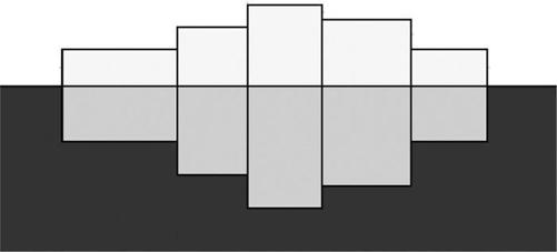
A cartoon showing how, according to the Airy hypothesis of isostasy, like blocks of wood floating in water, mountains stand high because they are thick. Their light ‘roots’ lie immersed in the more dense rock of the mantle, like the counterbalancing nine tenths of an iceberg below the waterline
The ocean floor, on the other hand, is made of denser rock. To change the analogy from ice to wood, if continents are light, like balsa wood, and stand high in the water, the ocean floor is like mahogany or teak: so dense that it floats, but only just. Hence, despite all that water on top of them, the oceans still exert more gravitational
attraction
than scientists had expected.