Supercontinent: Ten Billion Years in the Life of Our Planet (10 page)
Read Supercontinent: Ten Billion Years in the Life of Our Planet Online
Authors: Ted Nield

F
IGURE
1.-
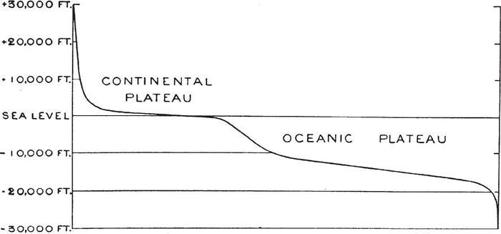
Generalized Profile, showing relative Areas of the Earth's Surface at different Heights and Depths.
The original ‘hypsographic curve’ by Grove Karl Gilbert, showing that the surface of the Earth lies mostly at two levels – average continent and average ocean. Mountains (extreme left) and ocean trenches (extreme right) account for very little of the Earth’s total surface area. Gilbert deduced that this graph said something fundamental about the way in which the Earth’s crust was organized. Reproduced by permission of the Geological Society of America, Boulder, Colorado © 1893.
Later it was discovered that if you make a graph of the Earth’s crustal elevation against the total area lying at that level, on this broad scale (at which small ups and downs can be neglected) the crust has only two basic levels. Continents are almost everywhere a few
hundred
metres above present sea level, and ocean basins are almost everywhere four to five kilometres below it. The continents have the odd mountain that’s very high and the oceans have the odd trench that’s very deep. But, basically, nearly all land is at one level and nearly all ocean floor is at another.
This is because ocean crust has its characteristic density and is the same everywhere (basalt), while continental crust is lighter and sits higher. And finally, there’s just enough water in the ocean basins to fill them, so nearly all continent is also land and nearly all ocean floor is under several kilometres of water.
This principle is called isostasy, but it is really no more than Archimedes’ Principle applied to rocks, which, contrary to all intuition, are all floating. Continents, despite what everyone thought they knew, and despite all the legends and myths, simply cannot sink. True, if you freight the land with thick ice sheets, then the extra mass of ice will gradually cause material underneath slowly to flow away. But when the ice melts, the deep, hot rock will flow back, and the land will rise again.
Although it took time, the idea of isostasy, of the buoyant balance of light and dense rock types, and the knowledge that, given time, the Earth is indeed soft to the touch, was what ultimately paved the way for a true understanding of how supercontinents form and disperse. They do it by moving sideways.
In 1896, acknowledging the Wollaston Medal, the Geological Society of London’s highest honour, the sixty-five-year-old Eduard Suess
wrote that it came to him ‘at an age when the natural diminution of physical strength confines me to my valley and my home; hammer and belt rest on their peg, and dreams and remembrances alone still carry me along those Alpine wanderings which form the highest charm of our incomparable science, and in the lonely grandeur of which Man feels himself more than ever a child of surrounding Nature’. His last years, devoted to writing his memoirs, were,
according
to the accounts, peaceful and happy.
Suess’s great book was completed nine years after he had retired from the university. His faithful servant, who had continued to bring and take away armfuls of books each day, quite unaware that his master had discovered a continent vaster than any man would ever see, looked at the foot-thick tomes, shook his head and said: ‘Is that all you managed to get out of those books I brought you?’
As a boy I inherited my father’s partwork encyclopaedia dating from about 1935, entitled
The World of Wonder
. This unwieldy tome contained popular and improving science and engineering articles. Edited by one Charles Ray, with copious but dingy black-and-white pictures and diagrams, it came in regular sections like ‘The Romance of Engineering’ or ‘Wonders of Land and Water’, punctuated by
illustrated
features with headings like ‘Inside a great Scotch boiler’ and my particular favourite, all about resonance, entitled ‘How a small girl can play a big trumpet’.
In year one of its publication, on page 172 there appears a short caption, set beneath three pictures: the Earth with its mountain ranges, a drying apple and an old man’s hand. It reads: ‘As the Earth gets older, its face wrinkles more and more, just as an apple wrinkles when it becomes dry and shrinks … and as the human skin wrinkles when a person becomes aged. Men of science are not agreed as to the cause of the Earth’s wrinkling. To some extent it is due to the
shrinking
of the Earth owing to the loss of interior heat …’
Suess’s cooling, shrinking Earth appeared to be still alive and well in the 1930s. But change was afoot. Turning to the
World of Wonder’s
page 731 (year two) you find another story, headed ‘The Drifting of the Earth’s Continents’. Three drawings show the world today, ‘3,000,000 years ago’ and ‘as it possibly appeared 200,000,000 years ago’: all lands locked together in one outline, one supercontinent, which we call Pangaea, and whose southern lobe bears the legend … ‘Gondwanaland’.
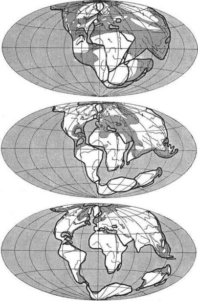
The iconic diagram by Alfred Wegener, showing Pangaea (consisting of Laurasia in the North and Gondwanaland in the South) slowly splitting up to form the continents we recognize today.
PART TWO
6
Geologist finds hole that lured Alice
THE TIMES,
15 SEPTEMBER 1999
‘Down, down, down. Would the fall never come to an end? “I wonder how many miles I’ve fallen by this time?” she said aloud. “I must be getting somewhere near the centre of the earth. Let me see: that would be four thousand miles down, I think—”’
Lewis Carroll’s
Alice’s Adventures in Wonderland
(1865) was
originally
called
Alice’s Adventures Underground,
and its opening chapter makes it easy to see why. But the geological connections of this tale may go deeper than Alice’s (fairly accurate) reflections on the radius of the globe.
Lewis Carroll was an Oxford University mathematics don, whose real name was Charles Lutwidge Dodgson. He was born in Daresbury, Cheshire, in 1832, the son of a local curate. The family later moved across the Pennines to Yorkshire when Carroll’s father became a Canon of Ripon Cathedral. In that cathedral town Charles senior had a friend and colleague named Canon Baynes Badcock. Badcock was the Principal of Ripon College, a Church of England teacher-training school established in 1862. He lived in a house called Ure Lodge, which
took its name from the river that flows through this prosperous market town.
The Badcock family included a young daughter by the name of Mary: the model, many believe, for Sir John Tenniel’s illustrations of Alice when
Wonderland
came to be published. Lewis Carroll, a
prolific
pioneering photographer, is said to have passed her picture to the artist. However, amid this Trollopean idyll of rural canons, Oxford dons and genteel pursuits, dark forces were at work.
The district around Ripon is renowned for an alarming geological phenomenon: the sudden appearance of deep, vertical pits, often ten metres or more across, that can swallow trees, gardens, garages and even homes in seconds. These holes are not usually much deeper than twenty metres (though that is deep enough when the remains of your house are at the bottom of it). Worse, though many are dry, some are filled with churning water. As landscape features they are unstable. Left to their own devices, they gradually widen out as their walls
collapse
, evolving into shallow, conical depressions that may become ponds, marshes or empty hollows. Then they tend to be forgotten.
The fields opposite Canon Badcock’s home displayed many
examples
of this phenomenon, both old and new. In 1837 a particularly big hole developed: one the young Carroll may have seen, either on a visit, or when his family moved to Yorkshire in autumn 1843.
The annals of the Diocese of Ripon record similar collapses down to the present day. And in 1997 local and national newspapers reported that on the 23rd and 24th of April a large crater opened up outside the house of Mrs Jane Sherwood-Britton in Ure Bank Terrace, within the garden of Canon Badcock’s former home. The great maw quickly swallowed up two out of a row of four garages, and narrowly missed Mrs Sherwood-Britton’s two children, who had been playing beside them only minutes before.
If you visit Ripon you will notice that on the parapet of the Town Hall is inscribed the pious motto ‘
EXCEPT YE LORD KEEP YE CITTIE YE WAKEMAN WAKETH IN VAIN
’. The annually elected Ripon Wakeman is an ancient office that may date back to Saxon times, though the earliest firm evidence is from 1515. In 1604, with the coming of a new City Charter, the Wakeman was restyled Mayor; but his original job was to keep the peace and act as watchman from the blowing of the Horn, in the Market Place at 9pm, until dawn. (The Hornblower,
incidentally
, still does his stuff today.)
The Lord may keep the city of Ripon, but to any inhabitant
unfortunate
enough to suffer from one of its occasional subsidences, the Lord is not much help. English law is distinctly quirky about landslip and subsidence, for which it holds landowners responsible, even though, you might think, such natural phenomena fit the bill perfectly as ‘acts of God’. As far as subsidence is concerned, landowners’ faith is better placed in geologists than the Almighty.
Nature rarely respects property boundaries, and legal argument at Ure Bank Terrace has since concentrated on demonstrating that no single proprietor can be held responsible for the whole of the hole, two of the four garages that vanished having belonged to two other people, one the modern owner of Canon Badcock’s Ure Lodge. And, bringing the story full circle, while the authorities were trying to find that elusive person (who has still to be identified), Ure Lodge itself also succumbed to local geology. Abandoned, empty and crumbling, it was finally transformed by workmen, who took it to pieces and recycled it.
The alarming tendency for bits of Ripon to vanish without
warning
down deep holes creates many civil engineering problems requiring close cooperation between engineers and geologists. Ripon now boasts a bypass, much of which is elevated above the River Ure on a reinforced embankment. The river flyover had to be designed so that it would remain standing should the ground suddenly vanish
from beneath any one of its many well-founded piers. This is
comforting
to the motorist, because holes like the one that almost swallowed Mrs Sherwood-Britton’s house appear on average once every three years, and (on a human timescale) are never going to stop.
In fact, if you tot up the combined volume of the thirty-five
subsidence
hollows that have formed in the past century and a half, it comes to at least 27,000 cubic metres, according to geologist Dr Tony Cooper. Cooper, an expert on the geology of the area, calculates that under each square kilometre of the Ripon district, at least thirty-six cubic metres of rock are dissolved every year by groundwater.
Tony Cooper recently retired as District Geologist for Yorkshire at the British Geological Survey, where he worked for thirty years. There is a boyish candour and enthusiasm about the way he talks about these alarming subsidences, and an obvious glee when, on his
computer
, he overlays digitized versions of historic maps one after the other to show how, over the decades, cartographers have mapped ‘pits’ that in later years became shallow depressions and then boggy hollows. Then there’s one map that shows a building on the site, the old pit now filled in and long forgotten. The modern technical
sophistication
of the Survey’s digital resources is a far cry, however, from the hammer, compass-clinometer, pencil and field-slip world of geology in the 1970s.
‘When I first joined the Survey I started mapping in Yorkshire,’ Cooper told me, ‘near York, then Wetherby, Knaresborough, Ripon and Bedale. I started to come across holes in the ground that I couldn’t explain. The first were south of Knaresborough. On the floodplain of the river, in a dead straight line, I found four craters. They were fairly sharp-sided, but they had no spoil heaps, so they didn’t look like
someone
had dug them. As I worked north towards Ripon I came across more, and started delving into the old literature. By 1982 I had sorted out the story, and come across quite a lot of other historical material’ –
including one Revd Tute and the paper ‘On certain natural pits in the neighbourhood of Ripon’ that he presented to the seventy-third
meeting
of the Geological and Polytechnic Society of the West Riding of Yorkshire in the Wakefield Church Institute one April night in 1869.
From the Revd Tute’s first steps towards a rational understanding of Ripon’s subsidence problems comes our modern knowledge that Ripon’s bedrock conceals layers of calcium sulphate – the soluble mineral known as gypsum (raw material for plaster) – in two thick strata.
Tony Cooper saw that prominent joints in the rock – natural
partings
and lines of weakness – were dictating the sites where dissolution of this gypsum was having the greatest effect. Rocks rarely have just one set of joints; they tend to occur in what are called conjugate sets, rather like the intersecting cardboard sheets in a case of wine. Where one set of joints intersects another, Cooper realized, dissolution was doubly enhanced. That was where the biggest caves formed, so giving rise to the regular, lattice-like pattern of sinkholes dotted about the landscape.
But Cooper was also responsible for another discovery, the link between Ripon’s unique geology and the world’s most famous
children’s
book. Lewis Carroll’s connection with Ripon was already well known: some of his characters were allegedly inspired by carvings on misericords in the Cathedral’s choir stalls. If you inspect the
misericord
under the Mayor’s seat (north side, east end) you will see a gryphon chasing two rabbits, an allegory of evil preying on the weak. One rabbit has been caught, but one has dived into its hole – you can see his little scut just disappearing into the Earth. Gradually, as Cooper pored over the old geological literature, he began to notice a recurring coincidence of collapses, clergymen and Lewis Carroll.
By 1997 Cooper’s notion about the link between Carroll’s
imaginative
landscape and the landscapes the writer had known as a boy
was growing stronger. He began reading up on the author’s life and while doing so he also noted an earlier, possibly significant
geological
association, with the village of Croft-on-Tees, south of Darlington, where the Dodgsons moved when Carroll was eleven years old. Barely a mile from where they lived are some mysterious (reputedly bottomless) ponds called Hell Kettles, one of which was formed by a dramatic subsidence in 1179. To this day, Hell Kettles are filled with water that rarely freezes, visibly steaming in the winter, and giving off sulphurous smells. As at Ripon, the subsidence was caused by gypsum dissolving underground. Such a local landmark and its diabolical legend could not have failed to come to the notice of the inquisitive young writer.
Cooper, who like Carroll is an enthusiastic amateur photographer, carries his enthusiasm for geology and landscape into many other fields, and this excursion into literary research was for him not that unusual. But his theory lacked an outlet until 1999, when the annual UK science festival organized by the British Association for the Advancement of Science rolled into Cooper’s
alma mater,
Sheffield University.
The tide of ideas that had been rising in Cooper’s mind for the best part of a decade had suddenly found an outlet. Sheffield University geologist Dr Mike Romano was charged with organizing the geology sessions and contacted him to speak about the recent Ripon
subsidence
. Cooper decided to enliven his story about gypsum dissolution by linking it to something everybody knew about:
Alice in Wonderland.
The rest is a small part of media history.
In fact, everything about Ripon’s civil engineering problems is
history
, except the modern technology to deal with them. The collapses happen because groundwater dissolves gypsum lying beneath the whole region. As caverns open up within it deep underground, their roofs begin to spall and stope their way slowly upward to the ground
surface. If you have ever removed a fireplace and then watched in horror as the bricks in the chimney-breast above fall out on to the floor, course by course, you have seen this process at work.
But how did the gypsum get there in the first place? To find that out we need to treat Alice’s rabbit hole as a time tunnel to Wegener’s lost supercontinent, just as it is beginning to break up.
Leaving behind Field View, Mrs Sherwood-Britton’s old house, you return to the main road at Ripon’s medieval North Bridge. Pausing to admire the piers of the new A61 Ripon bypass, with their invisible big feet, you turn through the city centre and head out on the B6265, due west, towards the Pennines: the backbone of England. Passing Royal Studeley, its deer park and Fountains Abbey World Heritage Site on your left, you take the turning to High Grantley and make your way up the rich, gently climbing farmland to High Skelding and Dallow Moor.
Quite suddenly, after the rich farms, their fertile fields and ancient hedgerows dotted with oak trees, the landscape begins to change. Drystone walls replace the hedges, and then themselves vanish as you pass on to the open moor underlain by Millstone Grit, Carboniferous-age rocks that were already deposited, hardened and folded into mountains, as the supercontinent of Pangaea assembled. They are humbler now, of course, after 250 million years of erosion; but as you walk up the heathery slopes to stand on a rough lump of Grit or in the lee of a sheep shelter and look down across the
lowlands
to Ripon, you are climbing the exhumed topography of Pangaea.
Close your eyes. You hear the wind over the heather, gorse bushes and hawthorns. Larks are rising. Mournful, far-off cries of birds of
prey drift across the hillside. It is time to follow the White Rabbit, and imagine his pocket watch racing backwards 250 million years.
You are now just two million years or so into what geologists have named (after the Chinese locality where its deposits are best
displayed
) the Wuchiapingian Age of the Late Permian. You, and those barren grey mountains of Millstone Grit behind you, whose roots will one day lie exposed to the boots of fell walkers, now sit about twenty degrees north of the Equator; the same latitude as Port Sudan, Timbuktu and Santiago de Cuba today. Although the Sun is slightly less luminous, it is searingly hot, perhaps in the upper forties. From the bare rock at your feet, you take in the slopes of brown, varnished boulders stretching to the plains, a sea of brownish dunes, up to fifty metres tall. Not everywhere down there is covered in sand; in some places rock desert pokes through, and in others, more low-lying, you can see greyish white: the salty fine mud of a desert playa. Towards the horizon its dirty white merges into the mirage. Towering greenish dust devils suck at the dry mud and, driven by the merciless Sun, carry it high into a sky where no bird has ever flown.