Iron Kingdom : The Rise and Downfall of Prussia, 1600-1947 (4 page)
Read Iron Kingdom : The Rise and Downfall of Prussia, 1600-1947 Online
Authors: Christopher Clark


Map 3. The Kingdom of Prussia at the time of Frederick the Great (1740–86)
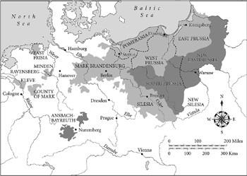
Map 4. Prussia during the reign of Frederick William II, showing the territories taken during the second and third partitions of Poland
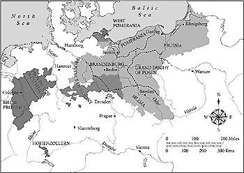
Map 5. Prussia following the Congress of Vienna (1815)
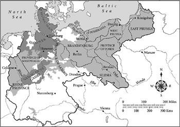
Map 6. Prussia at the time of the Kaiserreich 1871–1918
The Hohenzollerns of Brandenburg
In the beginning there was only Brandenburg, a territory encompassing some 40,000 square kilometres and centred on the city of Berlin. This was the heartland of the state that would later be known as Prussia. Situated in the midst of the dreary plain that stretches from the Netherlands to northern Poland, the Brandenburg countryside has rarely attracted visitors. It possesses no distinctive landmarks. The rivers that cross it are sluggish meandering streams that lack the grandeur of the Rhine or the Danube. Monotonous forests of birch and fir covered much of its surface. The topographer Nicolaus Leuthinger, author of an early description of Brandenburg, wrote in 1598 of a ‘flat land, wooded and for the most part swamp’. ‘Sand’, flatness, ‘bogs’ and ‘uncultivated areas’ were recurring topoi in all the early accounts, even the most panegyric.
1
The soil across much of Brandenburg was of poor quality. In some areas, especially around Berlin, the ground was so sandy and light that trees would not grow on it. In this respect little had changed by the mid nineteenth century, when an English traveller approaching Berlin from the south at the height of summer described ‘vast regions of bare and burning sand; villages, few and far between, and woods of stunted firs, the ground under which is hoar with a thick carpeting of reindeer moss’.
2
Metternich famously remarked that Italy was a ‘geographical expression’. The same could not be said of Brandenburg. It was landlocked and without defensible natural borders of any kind. It was a purely political entity, assembled from the lands seized from pagan Slavs during the Middle Ages and settled by immigrants from France, the
Netherlands, northern Italy and England, as well as the German lands. The Slavic character of the population was gradually erased, although there remained until well into the twentieth century pockets of Slavic-language speakers – known as ‘Wends’ – in the villages of the Spreewald near Berlin. The frontier character of the region, its identity as the eastward boundary of Christian-German settlement, was semantically conserved in the term ‘Mark’, or ‘March’ (as in Welsh Marches), used both for Brandenburg as a whole and for four of its five constituent provinces: the Mittelmark around Berlin, the Altmark to the west, the Uckermark to the north and the Neumark to the east (the fifth was the Prignitz to the north-west).
Transport arrangements were primitive. As Brandenburg had no coast, there was no harbour on the sea. The rivers Elbe and Oder flowed northwards towards the North Sea and the Baltic through the western and eastern flanks of the Mark, but there was no waterway between them, so that the residential cities of Berlin and Potsdam remained without direct access to the transportation arteries of the region. Work had begun in 1548 on a canal that would link the Oder with the river Spree that ran between Berlin and its sister-city Cölln, but the project
proved too costly and was abandoned. Since in this period transport was far more expensive by land routes than by water, the paucity of navigable east–west waterways was a serious structural disadvantage.

Brandenburg lay outside the main German areas of specialized crop-based manufacture (wine, madder, flax, fustian, wool and silk), and was not well endowed with the key mineral resources of the era (silver, copper, iron, zinc and tin).
3
The most important centre of metallurgical activity was the ironworks established in the fortified city of Peitz in the 1550s. A contemporary depiction shows substantial buildings situated among fast-flowing artificial watercourses. A large water-wheel powered the heavy hammers that flattened and shaped the metal. Peitz was of some importance to the Elector, whose garrisons depended upon it for munitions; it was otherwise of little economic significance. The iron produced there was prone to shatter in cold weather. Brandenburg was thus in no position to compete for export custom in regional markets and its nascent metallurgical sector could not have survived without government contracts and import restrictions.
4
It had nothing to compare with the flourishing foundries in the ore-rich electorate of Saxony to the south-east. It did not enjoy the self-sufficiency in armaments that enabled Sweden to assert itself as a regional power in the early seventeenth century.
Early accounts of Brandenburg’s agrarian topography convey a mixed impression. The poor quality of the soil across much of the territory meant that agricultural yields in many areas were low. In some places, the soil was so quickly exhausted that it could be sown only every six, nine or twelve years, not to mention sizeable tracts of ‘infertile sand’ or waterland where nothing could be grown at all.
5
On the other hand, there were also areas – especially in the Altmark and Uckermark and the fertile Havelland to the west of Berlin – with sufficient tracts of arable land to support intensive cereal cultivation, and here there were signs of real economic vitality by 1600. Under the favourable conditions of the long European growth cycle of the sixteenth century, the landlords of the Brandenburg nobility amassed impressive fortunes by producing grain for export. Evidence of this wealth could be seen in the graceful Renaissance houses – virtually none of which survive – built by the better-off families, a growing readiness to send sons abroad for university education, and a sharp rise in the value of agricultural
property. The waves of sixteenth-century German immigrants who came to Brandenburg from Franconia, the Saxon states, Silesia and the Rhineland to settle on unoccupied farms were a further sign of growing prosperity.
Yet there is little to suggest that the profits earned even by the most successful landlords were contributing to productivity gains or longer-term economic growth on a more than local scale.
6
Brandenburg’s manorial system did not release enough surplus labour or generate enough purchasing power to stimulate the kind of urban development found in western Europe. The towns of the territory developed as administrative centres accommodating local manufactures and trade, but they remained modest in size. The capital city, a composite settlement then known as Berlin-Cölln, numbered only 10,000 people when the Thirty Years War broke out in 1618 – the core population of the City of London at this time was around 130,000.
How did this unpromising territory become the heartland of a powerful European state? The key lies partly in the prudence and ambition of the ruling dynasty. The Hohenzollerns were a clan of south-German magnates on the make. In 1417, Frederick Hohenzollern, Burgrave of the small but wealthy territory of Nuremberg, purchased Brandenburg from its then sovereign, Emperor Sigismund, for 400,000 Hungarian gold guilders. The transaction brought prestige as well as land, for Brandenburg was one of the seven Electorates of the Holy Roman Empire, a patchwork quilt of states and statelets that extended across German Europe. In acquiring his new title, Frederick I, Elector of Brandenburg, entered a political universe that has since vanished utterly from the map of Europe. The ‘Holy Roman Empire of the German Nation’ was essentially a survival from the medieval world of universal Christian monarchy, mixed sovereignty and corporate privilege. It was not an ‘empire’ in the modern Anglophone sense of a system of rule imposed by one territory upon others, but a loose fabric of constitutional arrangements centred on the imperial court and encompassing over 300 sovereign territorial entities that varied widely in size and legal status.
7
The subjects of the Empire included not only Germans but also French-speaking
Walloons, Flemings in the Netherlands and Danes, Czechs, Slovaks, Slovenes, Croats and Italians on the northern and eastern periphery of German Europe. Its chief political organ was the imperial diet, an assembly of envoys representing the territorial principalities, sovereign bishoprics, abbeys, counties and imperial Free Cities (independent mini-states such as Hamburg and Augsburg) that composed the ‘estates’ of the Empire.
Presiding over this variegated political landscape was the Holy Roman Emperor. His was an elective office – each new emperor had to be chosen in concert by the Electors – so that in theory the post could have been held by a candidate from any eligible dynasty. Yet, from the late Middle Ages until the formal abolition of the Empire in 1806 the choice virtually always fell in practice to the senior male member of the Habsburg family.
8
By the 1520s, following a chain of advantageous marriages and fortunate successions (most importantly to Bohemia and Hungary), the Habsburgs were far and away the wealthiest and most powerful German dynasty. The Bohemian crown lands included the mineral-rich Duchy of Silesia and the margravates of Upper and Lower Lusatia, all major centres of manufacture. The Habsburg court thus controlled an impressive swathe of territories reaching from the western margins of Hungary to the southern borders of Brandenburg.