1491 (44 page)

The so-called Gateway of the Sun attracts pilgrims by the thousands who seek astronomical meaning in its location. Unfortunately, it was moved to its present site in the twentieth century.
Tiwanaku has been excavated for a century, and the more archaeologists delve into it the less there seems to be. To Vranich, the capital’s lack of resemblance to European imperial cities extends well beyond the absence of marketplaces. Far from being the powerful administrative center envisioned by earlier researchers, he says, Tiwanaku was a combination of the Vatican and Disneyland, a religious show capital with a relatively small population—almost a
staff—
that attracted pilgrims by the thousand. Like the tourists at the solstice today, visitors came to this empire of appearances to be dazzled and awed. “In the central city, buildings and monuments went up and down, up and down, at an incredible rate,” Vranich told me at Tiwanaku, where he had been working since 1996. “Nothing ever got finished completely, because they were just concerned with the facades. They had to keep changing the exhibits to keep the crowds coming.”
The encounter between Tiwanaku and Wari at Cerro Baúl seems to have gone remarkably smoothly. At any rate, a study of more than a thousand Wari and Tiwanaku graves found no evidence of the trauma associated with violence. Instead, the two societies split the region between them. Wari camped atop Cerro Baúl and a neighboring hillock, Cerro Mejía. Between them was a steep valley with Tiwanaku settlements scattered throughout. Because Wari and Tiwanaku pottery differed, Williams and Nash have been able to map which group lived in which neighborhood by the distribution of ceramic fragments. The Wari canal provided drinking water, but had to pass through Tiwanaku territory at the base of Cerro Baúl. Tiwanaku let the water through, but took enough to irrigate more than seven hundred acres of terraces.
At the same time, Wari and Tiwanaku kept themselves separate. Although they shared resources, there is little evidence that people from one culture visited the other often, or had friendships across the political lines. Wari homes were furnished with Wari goods; Tiwanaku homes, Tiwanaku goods. Despite living next to each other, people continued to speak their different languages and wear their different clothing and look for inspiration and instruction from their different capitals. The social-science word for such intermingling without intermixing is “interdigitization.” For two centuries at Cerro Baúl, Wari and Tiwanaku were like people in parallel worlds, sharing the same time and space but implacably separate from each other. It is a small reminder that Indians were neither the peaceful, love-thy-neighbor types envisioned by some apologists or the brutal, ceaselessly aggressive warriors decried by some political critics.
The end came in about 800 A.D., Williams told me. He was part of a Peruvian-American team that in 2005 reconstructed Cerro Baúl’s last days. As many as twenty-eight high-ranking nobles and priests gathered in the Wari colony’s biggest palace for a final feast at a great reception hall, thirty feet on a side, each wall lined with a stone-faced bench. The chamber opened onto what the archaeologists believed “was likely the chief executive’s office for conducting statecraft,” the Andean equivalent of the Oval Office in the White House. To judge by the scattered food remains, the goodbye party was a Rabelaisian affair, with platters of llama, alpaca, vizcacha (Andean hare), and seven types of fish, all washed down with fresh
chicha,
this last being served in huge ceremonial mugs, many heraldically decorated, that held up to half a gallon apiece of brew. At the end the drunken crew staggered through the palace, smashing the crockery and setting the whole place afire. “It looks like they had a really wild time of it,” Williams said. Last to go was the
chicha
brewery with its elite female staff. The lords torched the thatched milling room and then threw their great mugs into the flames. “Later, when the embers had cooled,” archaeologists wrote, “six necklaces of shell and stone were placed atop the ashes in a final act of reverence.”
The retreat was part of a general fall. Tiwanaku may have declined first, leading Wari to shut down its embassy in Cerro Baúl. Or perhaps Wari was pulling back for its own internal reasons. Both declines have been laid to drought, but this is contested. For one thing, Wari had already survived drought. As for Tiwanaku, Vranich said, “How much would drought matter to Disneyland?” Its ability to retain its audience would be far more important.
The successors to both Wari and Tiwanaku combined the former’s organizational skills and the latter’s sense of design and razzle-dazzle. First came Chimor, then the greatest empire ever seen in Peru. Spread at its greatest extent over seven hundred miles of the coastline, Chimor was an ambitious state that grew maize and cotton by irrigating almost fifty thousand acres around the Moche River (all of modern Peru only reached that figure in 1960). A destructive El Niño episode in about 1100
A.D.
made irrigation impossible for a while. In response, the government forced gangs of captive laborers to build a fifty-three-mile, masonry-lined canal to channel water from the Chicama River, in the next valley to the north, to farmland in the Moche Valley. The canal was a flop: some parts ran uphill, apparently because of incompetent engineering, and the rest lost nine-tenths of its water to evaporation and seepage. Some archaeologists believe that the canal was never meant to function. It was a PR exercise, they say, a Potemkin demonstration by the Chimor government that it was actively fighting El Niño.
When the bad weather ended, Chimor looked outside its borders. Armies went out and returned victorious to Chan Chan, the Chimor capital, a seaside metropolis with a dense center that covered four square miles. Dominated by nine high-walled imperial palace-tombs and five cathedral-like ceremonial complexes, the city was both exemplary in its grandeur and oddly empty, because its streets were restricted to the elite. Commoners were barred, except for a few specialized technicians and craftworkers. Each palace was hundreds of feet on a side and many were three stories tall. They were filled with storage space—living quarters were almost an afterthought. Their great beams adorned with splendidly worked gold and silver, the huge structures were jammed together around the center of town like people huddling in the shelter of an awning.
Chan Chan suffered a palace surfeit because dead rulers were regarded as divine figures. As with the Inka, the kings’ mummified bodies continued to live opulently in their own homes and could not be displaced; indeed, the mummies were necessary presences at important state occasions. As a result, each new ruler had to build his own palace and acquire the riches necessary to maintain it till the end of time. The system almost guaranteed imperial ambitions and exuberant construction plans.
The biggest of Chan Chan’s surviving palaces may have belonged to Minchaçaman—the eleventh king in the Chimor dynasty, according to one Spanish account—who reputedly conquered much of the coastline. Minchaçaman was a powerful figure who could have taken over even more land than he did. Unfortunately for him, he lived at the same time that a previously little-known group, the Inka, acquired a new ruler, Pachakuti. In about 1450 the Inka army, led by Qhapaq Yupanki, Pachakuti’s brother, besieged the city-state of Cajamarca, in the foothills east of Chimor. Cajamarca’s leader had allied himself with Minchaçaman, who rushed to his aid with an army. He does not seem to have known what he was in for, possibly because he viewed the Inka as a gang of rustic thugs. Qhapaq Yupanki awaited him in an ambush. Minchaçaman and his army were forced to flee as Cajamarca fell to the Inka. Qhapaq Yupanki covered himself with so much glory that when he returned home to Qosqo his brother, sensing future trouble, promptly executed him.
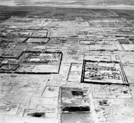
In this rare aerial photograph—taken in 1931, before modern looting blasted the site—the ruined Chimor capital of Chan Chan sprawls across the northern Peruvian coast. One of the wonders of the fifteenth-century world, Chan Chan abruptly fell to the Inka in about 1450; eighty years later, Spanish diseases and Spanish soldiers destroyed much of what had survived the Inka.
A decade or so later—in 1463, if Spanish chronicles are correct—the emperor sent out another army led by his son and designated successor, Thupa Inka Yupanki. By that time nobody thought of the Inkas as hicks. Thupa Inka descended the Moche River and paralyzed Chimor’s defenses by the simple expedient of threatening to destroy its water supply. Minchaçaman was captured, taken to Qosqo, and forced to watch Thupa Inka’s victory celebration. Chimor’s conquerors were quick studies. Liking the courtly magnificence of Chan Chan, they hauled away what they could and, more important, forced the city’s gold, silver, and gem workers to accompany them to Qosqo. They were instructed to transform the city into a new Chan Chan, only more impressive. Seven decades later, when Pizarro held
his
victory celebration in Qosqo, it was equal in grandeur to any city in Europe.
MAKING THE
WAK’A
Jonathan Haas and Winifred Creamer took me to Caballete, a narrow, dusty bowl, perhaps half a mile long and a quarter mile wide, a few miles up the Fortaleza River from the Peruvian coast. At the mouth of the bowl were three mounds in a rough semicircle that faced a fourth mound. In front of one mound, like a one-eighth scale model of Stonehenge, was a ragged circle of
wak’a
: sacred stones. Not far from the
wak’a
looters had dug up an ancient graveyard, pulling out the bodies and unwinding them from their sheets in a search for gold and jewels. When they didn’t find any, they threw the bones down in disgust. In a square perhaps fifty yards on a side the ground was carpeted with broken human bones and scraps of thousand-year-old fabric.
We walked a little further and were greeted by a curious sight: skulls from the cemetery, gathered into several small piles. Around them were beer cans, cigarette butts, patent-medicine bottles, half-burned photographs, and candles shaped like naked women. These last had voodoo pins stuck in their heads and vaginas. Local people came to these places at night and either dug for treasure or practiced witchcraft, Haas said. In the harsh afternoon light they seemed to me tacky and sad. I imagined that the families of the people who had been buried at Caballete so long ago would have been outraged if they could have known what would happen to the bodies of their loved ones.
The history of Andean societies is so rich and complex that it often leaves archaeologists feeling overwhelmed—there is so much to learn that they can never keep up. A single example: scientists did not confirm the existence of the Great Wall of Peru, a forty-mile stone rampart across the Andes, until the 1930s. And it still has never been fully excavated.
But then it occurred to me that my views may not have been shared by either the present or the past inhabitants of Norte Chico. I had no idea what people in Wari or Chimor would have thought of the scene before me. So far in this section, I have mainly described the economic and political history of Andean Indians. But people live also in the realm of the affective and aesthetic—that’s why they bury bodies and sometimes dig them up and pour love potions on them. Despite all the knowledge gained by scientists in the last few decades, this emotional realm remains much harder to reach.
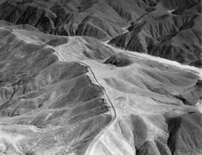
An obvious example on the southern coast is the Nazca, famous for the huge patterns they set into the ground. Figures of animals and plants, almost a thousand geometric symbols, arrow-straight lines many miles long—what were they for? Peruvian anthropologist Toribio Mejía Xesspe first brought these famous drawings to the attention of the outside world in 1927. Four decades later, the Swiss writer Erich von Däniken set off an international furor by claiming that the Nazca Indians could not have made these symbols, because they were too big for such “primitive” people to construct, and because they are visible only from the air. Instead, he said, the giant figures were landing signals for space travelers; the whole plain was a sort of gigantic extraterrestrial airport. Expanded in a series of bestselling books, this notion turned the lines into a major tourist attraction. Exasperated scientists pointed out that a) small groups could have constructed the images by moving the dark surface stone to expose the lighter-colored earth beneath, and b) the Nazca did not have to see the figures to experience them, for they can be understood by walking the lines, which it is believed the Indians did. The prevailing theory today is that the straight lines mapped out the area’s many underground faults, which channel water. But nobody knows why the Nazca made the animal and plant figures, which seem less likely to have a direct function. What were the Nazca thinking as they created them? How did they feel when they walked them? To this day, the answers remain frustratingly far away.